SHORT - SECTION ONE (STARTING POINT)
- Apr 12
- 9 min read
Updated: May 28

SECTION ONE: ORIGIN OF THE TWIN CITIES
RECOMMENDED TIME WINDOW: 11:00am - 11:10am
Disregard Time Window if doing A La Carte or at own pace

START POINT Mill Ruins Parking Lot 100 W River Pkwy, Minneapolis, MN 55401

MILL RUINS PARK We are currently standing on the strip of grass separating the parking lot and the river, taking in an amazing panoramic view of so many things: the Mississippi River, numerous bridges, the lock, towering skyscrapers, power plants, repurposed warehouses turned apartments, literal ruins! It's like we woke up from some limbo coma state and found ourselves in the middle of a crazy world, the middle of a vast ongoing story.

What I find so interesting about this spot is how "central" it feels. This location is a nexus of the past, present and future. Everything that led to the formation of the Twin Cities started right here. The rise and fall of industries happened all within this panoramic view. The Cities' place in the greater workings of the world can be observed in the ships going up and down the river. The future direction of the metro can be sussed out by just stopping, watching and listening to the countless amount of things going on around us. This is a special place. An overwhelming place. Stop. Take a breath. Just listen and look around for a minute . . . Focus now on the sound of waterfalls. You might not be able to see it from this current position due to the lock blocking it, but what you're hearing is the source, the epicenter, the location of the Big Bang of the Twin Cities: St. Anthony Falls. The only natural waterfall that was ever on the Mississippi (operative word being "was", as you'll ascertain below). In 1680, Father Louis Hennepin, a Belgian Catholic friar, famous for letting the Western world in on Niagara Falls, came upon these falls in his explorations of the Upper Midwest region. He named them "Chutes de Saint-Antoine", or Falls of Saint Anthony, after his patron saint, Anthony of Padua. His observations were published, and a spark of interest in the area was starting to ignite in Europe . . . The falls have been a significant cultural and sacred site to native tribes who visited and lived in the area. The Mdewakanton Dakota called the falls numerous names, including "mnirara", or "curling waters"; "owahmenah", or "falling waters"; "owamni", or "whirlpool". This last name, "owamni", is of interest, in that a wonderful restaurant nearby is so named "Indigena by Owamni", an Indigenous establishment which showcases true North American Indigenous foods and culture. It is one of the best restaurants in the Cities, and is featured in the Weekend version of Intro to the Twin Cities! With Europe's interest peaked, explorers were sent to document the falls, including Zebulon Montgomery Pike and Jonathan Carver, this latter being the first Englishman to write about the falls in what is regarded the first popular American travel book. Fort Snelling was established in 1820 down river at the confluence of the Mississippi and Minnesota Rivers, and tourists started to flock to see the falls, who were reportedly let down by the fact that they weren't as majestic as Father Hennepin led everyone to believe. Which brings me to a crucial point: the falls, while they may have been the catalyst for Western civilization and expansion in this region . . . the falls, admittedly, aren't that beautiful. They've been completely butchered by industries (textile mills, wool, machinery, paper, wood and flour). The mills at the falls created the country's greatest waterpower industrial district, and these industries were the cause of so many people flocking to come live here and prosper. Two towns were founded on both sides of the river: Saint Anthony on the east side, and Minneapolis on the west. In 1872, the two towns merged into one city: Minneapolis. So, the falls ain't Niagara levels of grandiose, but they were and are currently a hydropowerhouse for making money!
Now, I’ve laid claim that St. Anthony Falls is the Origin of the Twin Cities. It can be argued that Fort Snelling is the true Origin, being that its formation ceded land from the Native Americans and allowed for white settlement. Well, if the story was such that ONE city came from Fort Snelling, which could’ve been the case, naturally, I would say that the latter location was the Origin. One major city growing out of the confluence of the Minnesota and Mississippi Rivers makes the most sense geographically.
However, a Major Joseph Plympton, stationed at Fort Snelling, arguably abused his position using government loopholes and privileges. He knew that Saint Anthony Falls was going to be a business boom, and he wanted to claim the land adjacent to the east side of the falls. Upon the Dakota treaty becoming law in 1838, the land east of the Mississippi became available for claiming. Plympton came as fast as he could the day after the law was put into place. Upon getting to the land he wanted, he encountered Franklin Steele, who already claimed the land, having traveled through the night to the falls.
Outside of Plympton and Steele (who was the Fort’s storekeeper), other officers at Fort Snelling were seeking to claim land as well, including Captain Martin Scott and John Emerson. They were able to make map proposals, submitted to Washington, D.C., under the pretenses of made up but real sounding reasons (alcohol consumption, resources, civilian protection, etc.) to expand the boundaries of Fort Snelling and kick civilians out of the seminal areas that would be advantageous to take advantage of the river’s hydroelectric possibilities. Thus, civilians settled in two different areas to be outside of the boundaries of the Fort.
This plan fell through for Plympton, but the damage had been done. Two communities were growing: Minneapolis/Saint Anthony and Saint Paul. The area around the Fort remained undeveloped and preserved. The confluence is an extremely important place for the Dakota people, called Bdote, a place of creation, “where sky, earth and rivers come together”. So, Plympton inadvertently preserved the confluence through his shady machinations of land claiming. And, also inadvertently, created the TWIN Cities, all because he wanted to take advantage of Saint Anthony Falls’ possible power.
(I highly suggest reading “Becoming the Twin Cities: Swindles, Schemes, and Enduring Rivalries” by Drew M. Ross. In it, he goes through the history of why the Cities never became one entity, always because of shady entities scheming against others.) Two more points before we finally get a move on: Flour mills and the Lock and Dam right below us. Early development utilizing the power generated by the falls were mainly sawmills, but flour mills became the reigning champion. This fueled the development of railroads and banks. Minneapolis became known as "Mill City". The three main contenders in the Octagon of Flour were the Pillsbury-Washburn Flour Mills Company (later Pillsbury Flour Mills Company and now General Mills), the Washburn-Crosby Company (later General Mills) and Northwestern Consolidated Milling Company (later Standard Milling Company). In the end, General Mills became Supreme Champion, having merged with Pillsbury, but the only name on that merger is General Mills. They get the Championship Belt, in my book. Yet, we really haven't touched on the fact that you're standing in Mill Ruins Park. What in the sam hill happened here?

As you can probably tell, people were harnessing the power of the river and the falls, but they seemed to go at it with jerry rigged doohickey contraptions that almost always spelled some kind of disaster. The falls were in a constant state of erosion, having moved 1500 feet upriver since Father Hennepin’s time, so people tried to put a stop to it. Firstly, by a dam in 1848 headed by Franklin Steele. This caused a boom of industry in general since they had better control of the water power, but the influx of companies on both sides of the river caused inevitable pollution, logs escaping from their booms and banging into the falls, diverting the water made parts of the limestone cap dry which led to weathering effects, shafts and tunnels weakened foundations, which accelerated the erosion of the falls 26 feet per year between 1857 and 1868. It was found that the falls would erode away into rapids, unsuitable for water power.
The second attempt at heading off erosion was in the form of a protective wood timber apron, which dissipated the energy of the water and moved it away from the falls. This also took care of the unruly escaped logs. This lasted a year. Whoops. 1866 to 1867, which, if you look at the previous paragraph, meant it really didn’t help the 26 feet per year erosion level which lasted until 1868. The Corps of Engineers made one in 1880 that lasted until it was destroyed in 1952. Okay, progress. A concrete apron was made in its stead. But in the interim between 1868 and 1880, other problems were occurring.
The St. Anthony Falls Water Company approved a plan to build a tailrace tunnel that started below the falls, went under Hennepin Island (the land directly across from us and to the right), under the riverbed to Nicollet Island (the land off to our left), 700 feet above the falls. This tunnel would allow the island to have waterpower. But on October 5, 1869 the limestone cap was breached.
Water blasted out of the tunnel onto Hennepin Island, causing a 150-foot section to collapse into the tunnel. People tried blocking the spill with trees and timber. Ineffective. They built a huge raft of timbers. No dice. A wooden dam that would funnel water away from the tunnel was made. You guessed it, that didn’t fix it, either.
A fix came in the form of a concrete dike constructed by the United States Army Corps of Engineers. It was just above the falls and Hennepin Island. Completed in 1876, it cut off the tunnel and any bypass channels. They also solved the erosion problem, in the form of a wooden apron in 1880, and two low dams that same year on top of the limestone cap to keep it wet so it would no longer weather.
Cue all of the industries prospering astronomically now that the Frankenstein monster of aprons, dams and dikes were promising total control of the falls and water flow. But disasters were also occurring onshore!!
One particular flour mill on the south shore, the Washburn A Mill, of the Washburn-Crosby Company (later General Mills), opened for business in 1874. Four years later, in May 1878, a spark ignited flour dust in the air, which created a huge explosion that was heard 10 miles away, killed 18 people, leveled the building, and destroyed a good chunk of the riverfront business area.
Washburn set to rebuilding the mill, completing the most technologically advanced mill in the world in 1880. He installed ventilation systems and dust collectors to prevent flour dust buildups. Business was booming (in the preferred way, this time!)!
However, in 1928, equipment malfunction caused a fire to gut the wooden interior of the building. New concrete pillars and flooring were installed to prevent a fire. There’s definitely a pattern of disaster striking then learning from mistakes.
Eventually, due to transportation rates, tariffs, and energy technology, the flour industry moved out of Minneapolis, the old mills sliding into disuse. This particular mill closed in 1965.
Well, it couldn’t just be closed down, turned into a National Historic Landmark, and lived out its days peacefully. Nope, more fire!
In February 1991, another fire broke out, engulfing the entire building. All that was left in the end was the concrete interior and the stone exterior. Minneapolis decided to turn this final ruination into a museum, and you are currently standing in the park devoted to the exterior ruins!
Looking at the river, turn to your 4 o clock, and you’ll see the mill ruins. It’s an amazing museum, the Mill City Museum, which is visited in the Loreway “History of the Twin Cities: Origins” (COMING SOON).
And lastly, the big lock and dam just below us.
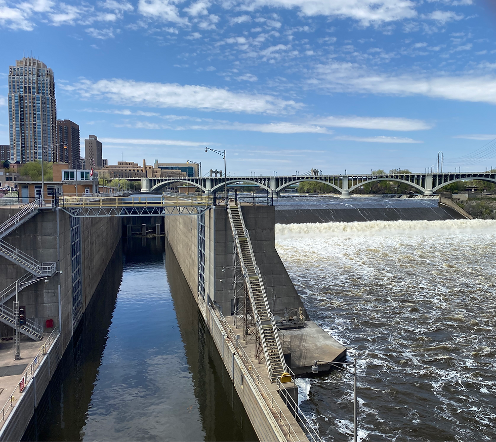
This is the Upper Dam, built in 1963. Another dam, the Lower Dam, is a half mile down river. These are part of a system of locks and dams that made commercial navigation possible upriver from Saint Paul, which was regarded the end of upriver travel until 1917, after the Ford Dam was completed. This dam (which we will see in Section 3 of this Loreway, it’s massive and awesome!) allowed boats to navigate up to Minneapolis. Then the Lower Dam was completed in 1956, followed by the Upper Dam in ’63, allowing for traffic to continue up to North Minneapolis’ industries along the river.
However, due to invasive species (especially Asian Carp), the Upper Dam was closed to stop the spread. So, below the falls is as far as you’ll be able to travel upriver on the Mississippi in one go from the delta. You’re looking at the end of the line, folks. Unless you portaged to above the falls. Otherwise, you’ll have to start above the falls on another commercial vessel.
But we haven’t even really begun on our line! It’s time to get moving. You’re probably pretty stiff just looking at this vast diatribe of a Starting Point. Had to happen, had to get all the preliminary origin stories out of the way. I’ll be much more brief and quick from here on out. ***Sources of information gathered for this section and for further reading if desired: -St. Anthony Falls - Wikipedia -Minneapolis - Wikipedia -"Becoming the Twin Cities: Swindles, Schemes and Enduring Rivalries" by Drew M. Ross -Mill City Museum
Let’s get walking!
CLICK HERE TO START WALKING SECTION 1
Comments