ONE DAY: MINNEAPOLIS + MOA - SECTION THREE
Updated: Aug 14

THREADING
THE
NICOLLET NEEDLE
RECOMMENDED TIME WINDOW: 10:50am - 11:50am
Disregard Time Window if doing A La Carte or going at own pace
WALKING DISTANCE: 2 miles
Personal car users: Feel free to spend a little more time at the garden. You will be skipping this section (unless you're up for a bit of out and back walking, out into downtown, back to your car). I’d suggest parking at the Portland Avenue Ramp near Mill Ruins Park to pick up Section Four, which starts at 11:50am.
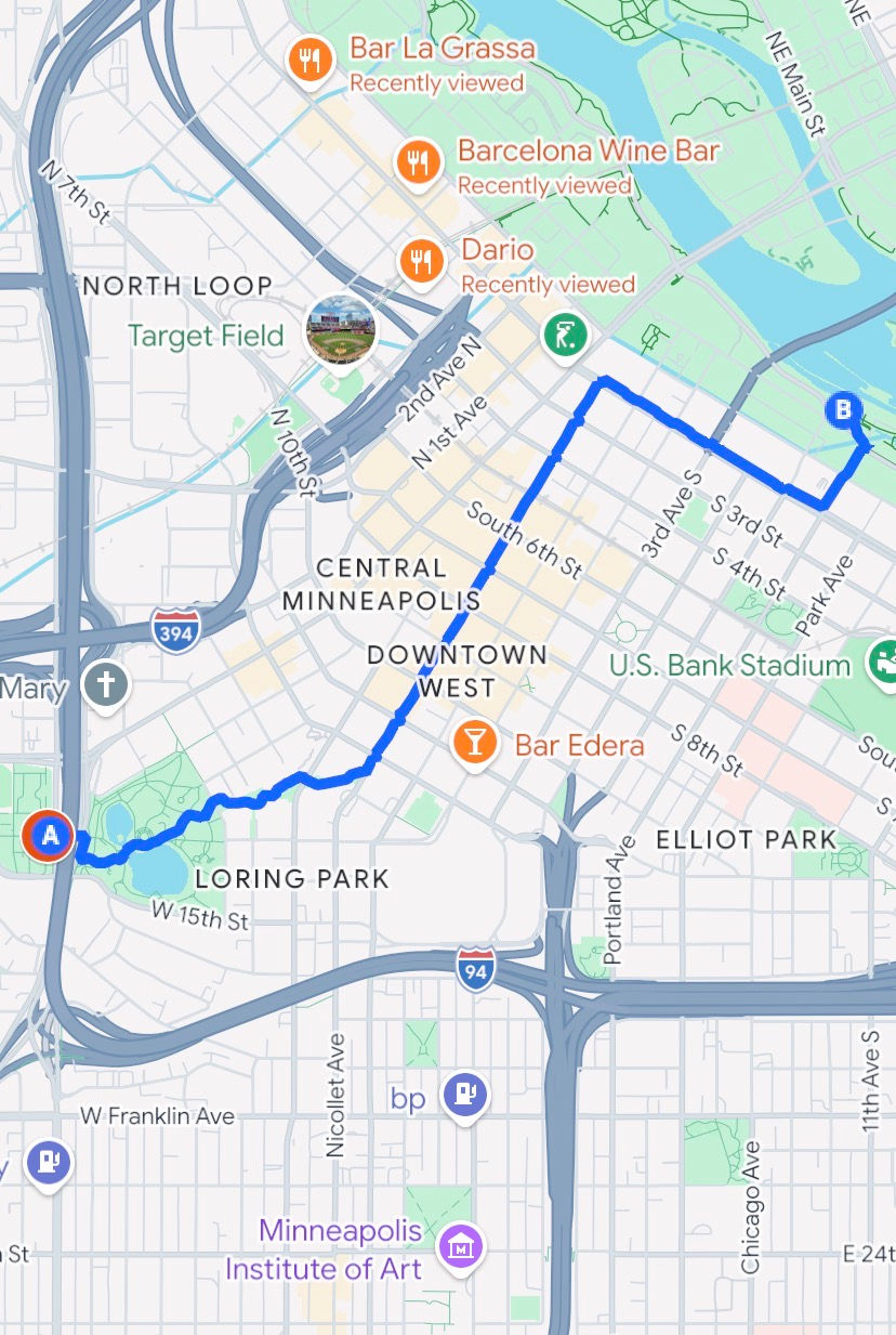
We’re about to walk from one end of downtown to the other, our destination being the Origin Center of the Twin Cities! We’ll get a really awesome and thorough look into a large portion of downtown Minneapolis in the process.
The aforementioned Irene Hixon Whitney Bridge was finished in 1988, designed by Siah Armajani. It connects the Sculpture Garden to Loring Park. Across the span of the bridge is an untitled poem by John Ashbery. A funny little note about this poem: “Walker Art Center staff joke that the Ashbery untitled poem . . . is the ‘longest poem in the world’ since the bridge stretches over 16 lanes of interstate traffic for 375 feet.” (Minneapolis Sculpture Garden Wikipedia)
Go up and over the bridge. Go down the ramp, not the steps. Stop once you come to the other side: Loring Park.
LORING PARK This park was established in 1883, when it was called Central Park. The name was changed in 1890 in honor of Charles Morgridge Loring, the first president of the Minneapolis Park and Recreation Board, nicknamed the “Father of Minneapolis Parks”. It was the first land purchased by the city to make a park.

It’s a modest sized 33.94 acres, a great little green gem in the middle of the metro. This is the center of Twin Cities LGBTQ+ Pride Festival in June, the Loring Park Art Festival in July, and the Holidazzle during the holidays.
From our position at the southwest end of the park, let’s move east with a horseshoes play area to our right.
Walk around the circle and onto the little bridge over the little channel in Loring Pond.
Skirt the southern edge of the Garden of the Seasons.
We’ll soon have the Berry House on our left (former office of William Berry, the first park superintendent in Minneapolis, constructed in 1883).
Let’s make our way around the shuffleboard court and up the small hill. Pass the left side of the Berger Fountain, also known as the Dandelion Fountain (built by Robert Woodward in 1971, installed in ’75, a copy of the Sydney fountain, El Alamein Fountain).
We’ll cross a crosswalk and continue on a path called the . . .
LORING GREENWAY
Stop just a sec on the other side of the crosswalk. If you're not sure you're at the right spot, there's a sign right next to the path designating it the "Loring Greenway".
This 1500 foot pathway we’re about to traverse was constructed in 1979 and serves as a really cool little throughway between Loring Park and Nicollet Mall, which is where we’re headed.
We’ll pass between tall apartment buildings, over bridges, sneak past small gardens and little playgrounds. It’s a peaceful and fun pathway in the middle of downtown that feels very isolated from the streets.

We’ll meander on a slightly northeast course through the trees, buildings and a lot of stone volcano structures. We’ll know we came to the right place when we see a final volcano looking fountain and then a pedestrian street.
Now, head on through and stop at the aqueous volcano near the street just to the left of the Hyatt Regency.
NICOLLET MALL
This narrow street is a pedestrian only street, save for buses and emergency vehicles. Nestled along both sides are an amazing array of restaurants (including Brit’s Pub - the best rooftop patio in Minneapolis complete with awesome international futbol watching and lawn bowling!; Dakota Jazz Club, coolest jazz club in the metro; The News Room - a newspaper themed restaurant that really pays homage to All That's Fit to Print!; The Local - a great Irish pub).

We’ll also pass the Minnesota Orchestra, the local CBS station studio, the IDS Center (highest building in Minnesota at 910 feet), the Mary Tyler Moore statue (throw your hats!), the Minneapolis Central Library and the Four Seasons Hotel Minneapolis.
One safety note: there is a higher presence of homeless on this street, and they are especially centralized across the street from Target on the left side of Nicollet and 9th. I’d say cross over to the right side of the street after reading this. Cross to the left side at Dayton's if you want a picture with Mary Tyler Moore.
Enjoy threading the Nicollet needle through Minneapolis!! Once Nicollet Mall ends at Washington Avenue at a T-junction, stop and read the following:
GATEWAY TO THE MILL DISTRICT
We’re getting closer to the Origin Point. We’re currently in The Gateway district of downtown. We’re heading for the Mill District. Why is it called the Mill District? What does that have to do with the Origin Point?? Walk on!
Turn right on Washington Avenue, heading southeast.
We’ll pass the cool Depot building, former train depot turned hotel and event center.
Cross 5th Ave S.
A block after The Depot and 5th Ave S, turn left on Portland Ave.
Walk two blocks to the Mill Ruins Park sign.
We've reached the Origin!!!!!!
Comments